
Seattle Neighbors Through Block Records
Public sources describe a Seattle block in layers. Parcel records identify lots and property roles. Dated directories show a snapshot of names at addresses. Permit data explains changes to a building, and neighborhood pages add civic context. No source is a complete current household list.
| Source | Block evidence | Access channel |
|---|---|---|
| King County Parcel Viewer | Adjacent parcels, taxpayer, jurisdiction, lot and building facts. | Free map, selection, buffer, and export. |
| eReal Property | Owner role, site address, legal description, and building detail. | Free address or parcel search. |
| House and Street Directory | Dated names and businesses by street segment. | SPL digital and library holdings. |
| SDCI permit history | Projects, status, team roles, and building changes. | Online report; older records by request. |
| City neighborhood pages | Reporting areas and public organization leads. | Online starting lists with cautions. |
A taxpayer may receive mail elsewhere, and a permit applicant may be a contractor. A directory name belongs to one edition. Treat each item as a dated role. That method reveals the block without inventing who occupies a private home.
Seattle Parcel Viewer Controls
The King County Parcel Viewer accepts an address, parcel, condo name, or intersection. A result may show site address, jurisdiction, taxpayer, present use, lot area, levy code, units, and buildings. The map can add parcels, set a buffer, measure, toggle labels, and export results.
Save the target address, adjacent parcel IDs, buffer setting, layer, and date. Lines are approximate. The taxpayer field is a tax role, not proof that the person is one of the current Seattle neighbors.
Open the Property Report and Districts Report links for each selected parcel when the block question calls for them. They can add present use, property name, appraised value, lot area, levy code, and service geography. King County iMap supplies another route through address, parcel, intersection, and landmark searches, with aerial vintages and thematic layers. Compare the same map scale and layer set for every lot so one parcel is not judged from richer data than the next.
The official parcel map displays the block controls.
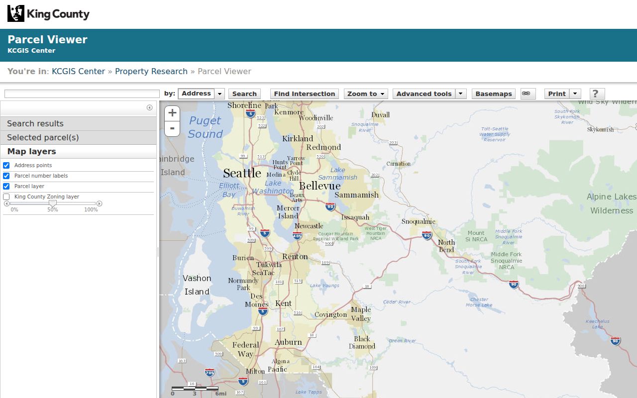
The map makes adjacency visible, but each record still needs its role and date.
Map a Seattle Block Outward
Start with one verified Seattle address. Map the immediate block and its public property relationships without collecting private contact details. Move from the target parcel to touching lots, then check each through the same official sources.
- Normalize the house number, direction, street, type, suffix, and unit.
- Locate the point and record its parcel and jurisdiction.
- Add touching parcels or a small buffer, then export the parcel set.
- Open each parcel in eReal Property and label owner, taxpayer, situs, and mailing fields.
- Check permits and a dated directory only for a lawful historical or civic purpose.
For one road from intersection to intersection, use the fuller Seattle street directory workflow. A neighbors search stays focused on nearby parcels and shared block context.
Historic Seattle Neighbors by Block
The 1928 Seattle House and Street Directory supports a criss-cross search. Choose a segment between two cross streets, transcribe both sides, then follow each name to the ordinary alphabetical directory. Compare the next edition and verify the building with a Sanborn map, parcel card, or permit.
This creates a dated block snapshot, not a current neighbor list. A shared address may be an apartment, boarding house, shop, school, church, or mixed-use site. Preserve the edition, page, side of street, and printed unit before making a connection.
Seattle's grid makes cross streets important. Downtown often lacks a directional prefix, while W commonly points to Magnolia or Queen Anne and should not be read automatically as West Seattle. Historic books may abbreviate the street type or omit a direction. Normalize the address in a separate field, but retain the printed form. Then compare an adjacent address and the City street maps before deciding that two entries belong to the same block.
Seattle Permits Around the Block
The SDCI Permit and Site History tool searches by address or map point and combines current and legacy systems. Reports can show projects, status, inspections, related permits, and documents. The complaint search offers date, record number, type, status, and structured address fields, with coverage described from November 10, 2003.
A complaint may be anonymous or confidential and can concern a nearby site. It is not a finding of wrongdoing. Many records after January 1, 2006 are electronic. Older permits and some plans need microfilm or a written request. Use these sources to explain building change, not to profile Seattle neighbors.
The complaint interface includes a create-date range, record number, type, status, address range, prefix, street, type, and suffix. Those fields can keep a block search narrow and reproducible. Older or non-online permit material should be requested with a precise address and permit number when known. Seattle's public-record center is another documented route for city-held records outside the portal, but the request itself can become public, so avoid names or private detail that the record search does not require.
Seattle Community Group Leads
The Department of Neighborhoods organizes public community groups by council district. Area buckets include Ballard, Magnolia and Queen Anne, Northwest, North, Northeast, Lake Union, East, Central, Downtown, Southwest, Delridge, Southeast, and Greater Duwamish. Some areas overlap.
| Area | Public context | Caution |
|---|---|---|
| Ballard and Northwest | Meeting, group, and local-history leads. | District and neighborhood lines differ. |
| Downtown and Central | Civic groups for dense, mixed-use blocks. | One address may have many units. |
| Southwest and Delridge | West Seattle community leads. | A label is not a postal boundary. |
| Southeast and Duwamish | Groups for long corridors and industrial areas. | Waterways and parcel uses complicate blocks. |
Use a public meeting page or group contact for civic context. These are starting lists, not authoritative boundaries. Membership never proves that a person lives at an address.
A community group is most useful for public facts about a place: meeting notices, local projects, neighborhood history, or the name residents use for an area. Do not copy a roster into a neighbor file or turn an organizer's mailing address into a residence claim. When districts overlap, retain the district page and the group's own stated service area. Then return to the parcel report for the exact lot rather than stretching the group label across the whole block.
Seattle Neighborhood Lines Differ
Seattle publishes 53 census-based Community Reporting Areas. Residents also use names such as Capitol Hill, Ballard, Beacon Hill, Georgetown, Lake City, Queen Anne, and West Seattle. Council districts, ZIP codes, CRAs, parcel jurisdictions, and community names draw different shapes.
Record the geography each source uses. A parcel report establishes jurisdiction and district. A city snapshot supplies a repeatable reporting area. A community group adds local history. None proves that every nearby lot shares the same identity or association.
Note: Publish both labels when a Seattle neighborhood name conflicts with the official reporting area used for the block.
Seattle Block Source Comparison
Official records and commercial neighbor compilations answer different questions. Official sources state a record role, date, custodian, and often a parcel identifier. Commercial compilations can merge old addresses and names without a clear source date. Treat that category only as an unverified lead.
| Trait | Official record | Commercial compilation |
|---|---|---|
| Role | Taxpayer, owner, applicant, or dated entry. | Relationship may be unclear. |
| Date | Record date or edition is shown. | Refresh date may differ from source date. |
| Correction | Custodian procedures apply. | Provider-specific and often opaque. |
| Best use | Documented property, civic, or historic fact. | Possible lead needing independent proof. |
Privacy Limits for Seattle Neighbors
My Voter Information requires a resident to match three of four fields and is not a neighbor search. Voter-list use is governed by RCW 29A.08.720, including a ban on advertising, offers, and solicitation. Do not assemble street lists from self-service voter tools. Parcel and directory sources provide better block context.
Washington's Address Confidentiality Program supplies substitute addresses to eligible protected people under chapter 40.24 RCW and chapter 434-840 WAC. Participation is confidential. If a protected address or sensitive clue appears, stop. Never infer an actual address or publish a private organizer's home contact.
Voter material has a narrow role here. King County My Voter Information is designed for a resident's own status and ballot details after matching three fields from first name, last name, birth date, and house or building number. It is not an address-to-names tool. Even a lawful statutory voter-list request remains subject to use limits and protected fields. For block research, rely on parcel geometry, dated directories, permits, and public civic pages instead.
Lawful use. Use Seattle neighbor records for civic context, local history, or personal safety awareness. Never use them to watch, harass, intimidate, or expose a private person.
Keep a Seattle Block File
A reproducible file retains the target address, cross streets, adjacent parcel numbers, buffer setting, map layer, directory year and page, permit IDs, historic street name, and exact neighborhood geography. Save source dates because parcel data and civic pages change.
Use careful labels. A parcel touches another parcel; that does not prove two households know each other. A directory name belongs to one edition. A public organization describes a civic network, not a private roster. Those limits make the result useful and protect your Seattle neighbors from unsupported claims.